Our bi-monthly newsletter has the latest news and updates.
Public information meeting scheduled for Cherokee Golf Course renovations
The Wisconsin Department of Natural Resources has announced a public information meeting concerning a permit application for the proposed Cherokee Golf Course renovations:
Notice of Pending Application/Public Hearing for Proposed Wetland Individual Permit, Connected Enlargement, Dredging and Stream Relocation Individual Permits
Dennis Tiziani, authorized representative of Cherokee Park, Inc. 5000 N. Sherman Avenue Madison, WI 53704, has applied to the Department of Natural Resources for a Wetland Individual Permit for wetland fill or disturbance and associated Individual Permits for the creation of a Connected Enlargement, Dredging, and Stream Relocation of an unnamed tributary stream to the Yahara River (WBIC: 806300), in the Town of Westport, Dane County.
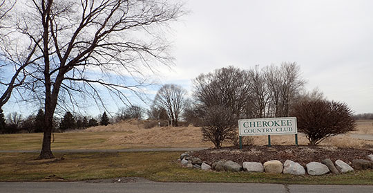
The project is located on the Cherokee Country Club at address 5000 N. Sherman Avenue Madison, WI 53704, near the Cherokee Marsh Conservation Park in the Eastern Y2 of Section 24, Township 08 North, Range 09 East, in the Town of Westport, Dane County.
The project involves a complete reconstruction and redesign of the Cherokee Golf Course. The course will be redesigned, including lengthening holes, widening playing surfaces, and expanding of ponds connected to a tributary of the Yahara River. These activities will result in 2.13 acres of wetland impact by either filling or excavation. The overall elevation of the fairways and playing surfaces will be raised to improve playing conditions and site drainage. Maintenance dredging of the waterways through-out the site will occur along with a rerouting of one section of the tributary stream in the southwest corner of the site. Four main connected enlargements will be constructed by deepening and widening existing ponds
and other waterways on site. A total of 192,069 cubic yards of dredge material would be removed from existing waterways and by creating connected enlargements. The dredge spoils will be disposed of on the course for raising the grade. Additional clean fill material will be brought in from offsite. Numerous perched culverts for the cart path will be removed and replaced with clear span bridges or larger culverts. A total of 1.64 acres of wetland will be created from turning upland areas into wetland, and vegetation enhancements and invasive species will occur on the other 33.5 acres of wetland on site. The proposed plans are labeled concept 9.
The Department will review the proposal provided by the applicant and any information from public comments and the public informational hearing. The Department will determine whether the proposal complies with ss. 1.11, 30.19, 30.195, 30.20, 281.36 and 30.208, Wis. Stats., and Ch. NR 103, 150, 151, 343, 345, 347, 350 Wis. Adm. Code, and ensure that the required mitigation meets the standards ins. 281.36(3r), Stats. if the project impacts wetlands.
The Department has made a tentative determination that it will issue the permit or contract for the proposed activity.
If you would like to know more about this project or would like to see the application and plans, please visit the Department’s permit tracking website at
https://permits.dnr.wi.gov/water/SitePages/Permit%20Search.aspx
and search for
IP-SC-2021-13-01717
The permit application is titled:
Narrative and Alternatives Analysis_01717_01719_03661_03662.pdf
Reasonable accommodation, including the provision of informational material in an alternative format, will be provided for qualified individuals with disabilities upon request.
The public hearing is scheduled for:
Wednesday November 17, 2021 at 4:00 PM – 6:00 PM
Westport Town Hall-Kennedy Administration Building
6387 Mary Lake Road, Waunakee, WI 53597
A virtual option for the hearing will also be available at the same date and time.
The hearing will be conducted with a Department hearing examiner. The hearing will be available via audio and or video means through the following website links:
Join Zoom Meeting:
https://us02web.zoom.us/j/81949060868
Meeting ID:
819 4906 0868
Alternatively, you may participate by phone:
1(312)626-6799
Meeting ID:
819 4906 0868
To help in the planning process, please consider sharing your intention to participate in the hearing at
https://www.surveymonkey.com/r/YMD63TM
You are not required to complete this survey to participate, but it will help in the planning process.
The Department scheduled a public hearing on this activity or project because the Department received a request for a public hearing from the applicant. The hearing will be a public informational hearing where members of the public can learn more about the proposed activity and submit written or oral comments about the waterway and project in light of the legal standards above. Any member of the
public may submit written comments by emailing Ryan.Pappas@wisconsin.gov or writing to Ryan Pappas, 1155 Pilgrim Rd., Plymouth, WI 53073 by U.S. mail. Comments should include the docket number (Docket # IP-SC-2021-13-01717; 01719) or applicant name (Cherokee Park, Inc.) and should relate to whether the project meets the legal standards listed above. Comments must be postmarked no later than December 3rd, 2021, in order for them to be
considered.
The final decision may be appealed as indicated in the decision document Docket Numbers: IP-SC-2021-13-01717; -01719; -03661; -03662
STATE OF WISCONSIN DEPARTMENT OF NATURAL RESOURCES
For the Secretary
BY:
Ryan Pappas
Water Management Specialist Date: November 3rd, 2021
***
More information
Tree removal plan for the golf course. (Tree removal has begun.)
Project history
Read about the announcement for plans to modernize the Cherokee Golf Course in our April / May 2021 newsletter,
Read about the DNR’s request for more information for the permit in our June / July 2021 newsletter.
Friends submit comments on golf course permit application – Aug / Sept 2021 newsletter.
Revisions made to Cherokee Golf Course plan
 We’ve reported previously on the proposed plan to renovate the Cherokee Golf Course, located in the Town of Westport. Westport’s Plan Commission requested a response to the concerns we raised about the renovation.
Jeffrey Kraemer of Heartland Ecological Services provided this response:
Cherokee has made revisions to their proposed project to further minimize wetland and waterway impacts. Wetland impacts have been reduced from nearly 10 acres to approximately 2 acres and all impacts to waterways through filling (1.33 acres) have been eliminated. Cherokee still proposes dredging of waterways for maintenance and water quality improvements; deep excavation and enlargement of a few of the existing ponds for water quality and obtaining construction fill material; and will be replacing undersized/perched culverts with appropriately sized and placed culverts while incorporating many clear span bridges and boardwalks to minimize wetland impacts. Cherokee is also proposing to restore all the wetlands on their property (33.5 acres) plus will create wetlands on-site to offset the wetland loss while also purchasing wetland mitigation credits.
Our response to the Friends of the Cherokee Marsh questions are as follows:
1. “The Cherokee Marsh wetlands provide crucial flood control and filtering of stormwater for Lake Mendota, the other downstream lakes in the Yahara chain, and their residents. Any loss of wetlands reduces the wetlands’ capability to provide these functions. We understand that the proposed 9.82 acres of wetland loss would be offset with wetland mitigation credits, but if the mitigation occurs in another watershed as expected, Cherokee Marsh and its downstream waters receive no benefit to offset the wetland loss.” Please describe where might the mitigation credits be used and how might the mitigation enhance the Marsh.
- Cherokee’s revised plans have further minimized wetland impacts from 9.82 acres to 2.06 acres. Of the proposed wetland impacts, 1.31 acres will result in a wetland loss through conversion to uplands, while 0.75 acres of wetland impacts will result from excavation activities and will result in a conversion of wetland type but not a loss. Cherokee’s on-site wetland mitigation plan is as follows and is detailed in a wetland restoration plan as part of the material at the link above:
| On-Site Wetland Restoration Methodology | Acreage |
| Establish Native Shoreline/Littoral Vegetation on Enlarged Waterbodies | 1.31 |
| Meander Channel Abandonment Restoration | 1.45 |
| Wetland Creation Within Uplands | 1.64 |
| Enhancement of Degraded Wetlands | 33.52 |
| Total Wetland Restoration and Enhancement | 37.92 |
As indicated, 1.64 acres of wetlands will be created on-site which will off-set the 1.31 acres of proposed wetland loss, while the restoration and enhancement of 36.28 acres of degraded wetlands and littoral zones will result in a significant overall beneficial impact to the ecological functional and values of the wetlands on-site. Furthermore, Cherokee will be required to purchase wetland mitigation credits at a likely ratio of 1.2:1 from a mitigation bank located within the Rock River watershed. This credits will be purchased from a private mitigation bank where the wetlands have already been restored.
2. “The application also requests to convert 1.3 acres of shallow open water to upland. The Wisconsin Department of Natural Resources (WDNR) strongly discourages the conversion of open water to upland as it is likely to be detrimental to the public interests of navigable waterways.” Please describe the shallow open water being converted and how the conversion might actually enhance the Marsh.
- Waterway conversion to uplands has been eliminated from the proposed plan. Further efforts have been proposed to avoid impacts to waterways through the use of clear span bridges and replacement of undersized and perched culverts. Maintenance dredging throughout the waterway channels are proposed to removed unconsolidated sediment that has accumulated overtime, which will limit the movement of this material downstream into the Yahara River, while improving fish passage and aquatic habitat.
3. “The WDNR’s Endangered Resource Review identified two species potentially present within proximity to the project area and provided required actions to comply with federal/state endangered species laws. Several other special concern, species of concern, and threatened species were identified as potentially being present, and recommended actions were presented to avoid impacts to these species. We urge consideration of these actions when evaluating the permit application.” Please describe steps Cherokee will be taken to address endangered resources in the project area to relieve the fears of the public in any potential loss of these species.
- Cherokee has coordinated directly with the WDNR Endangered Resources program staff and they have determined that the proposed project will not impact any known or potential rare species. WDNR has provided mitigation measures that Cherokee must adhere to during construction to avoid any potential impacts. Overall, Cherokee will be improving habitat, both wetland and aquatic, including habitats that support species of special concern, threatened and endangered with their proposed project. The information provided by WDNR specific to threatened and endangered species is confidential and unfortunately Cherokee is unable to provide specific details, but the WDNR determined that by using appropriate construction practices and timing no impacts would be expected.
We will continue to follow and report on this project.
Project history
Read about the announcement for plans to modernize the Cherokee Golf Course in our April / May newsletter,
Read about the DNR’s request for more information for the permit in our June / July newsletter.
Friends submit comments on golf course permit application – Aug / Sept newsletter.
Presentations from the Cherokee-Yahara River Estuary Rehabilitation Project and public survey
The presentations from the Cherokee-Yahara River Estuary Rehabilitation Project are now online along with a public survey.
Friends of Cherokee Marsh comments on developing a long-term plan for a portion of the Cherokee-Yahara River Estuary
Here are the comments submitted by the Friends of Cherokee Marsh in response to the public meetings on developing a long-term plan for a portion of the Cherokee-Yahara River Estuary.
The Friends of Cherokee Marsh appreciate the interest taken by Dane County, UW Civil & Environmental Engineering, the DNR, City of Madison, and others in the health of the upper Yahara River at Cherokee Marsh.
We will welcome projects that help stem continued loss of shoreline wetlands at Cherokee Marsh and provide other benefits.
Steering committee
We are disappointed that the Friends of Cherokee Marsh were not asked to participate in meetings of the Cherokee Steering Committee as the grant specifies. We request to be included as participants in all future communications and meetings of this committee.
We strongly recommend that any proposal put forth by the steering committee includes analysis from wetland ecologists that have experience with the upper Yahara or similar peat wetland ecosystems. We can’t support proposals that don’t include input from these sources.
Alternative concepts
The grant states that the team will explore several concepts for restoring Cherokee before proceeding to analysis in Phase 2. Yet the peninsulas concept is the only one apparently under consideration. We believe that considering a range of options will help ensure that the selected plan will be effective, affordable, and supported by the public.
We have substantial reservations about the idea of dedicating the upper Yahara and Cherokee Lake as a catch basin for nutrient-rich sediment. We support the work by the county and others to address conditions that are producing sediment in the river.
The grant states that the FBI structures were successful in stopping shoreline erosion. Yet this project has been abandoned, leaving the structures to work loose and float away. We are concerned that future projects may suffer the same lack of maintenance over time.
From our observations as well as the data presented at the public meetings, the beds of American lotus and other submergent and emergent plants established in the last 15 years have been effective at calming the water, protecting the shorelines, capturing sediment, and providing wildlife habitat. Before planning a major construction project with similar goals, we recommend continued and expanded documenting of shoreline erosion or buildup, vegetation, sediment capture, and other indicators of ecological health in different seasons and rainfall patterns. This information will help to better understand what areas are in need of attention and what strategies might be effective.
We support continued carp harvests as needed.
Peninsulas concept
These are our concerns about the peninsulas concept as presented.
We’ve seen no evidence that the peninsulas concept has been examined by wetland ecologists who can address concerns such as those we present below.
The shoreline wetlands in the Cherokee Marsh flowage (the area of the Yahara upstream from Lake Mendota and flooded by the Tenney Park dam) are fragile because they are floating, not rooted in the river bed, and only loosely attached to adjacent vegetation. Rapidly changing water levels due to storm events cause these wetlands to rise and fall as if on hinges. The force of repeated motions of this type results in the wetlands breaking off and floating downstream where they fall apart and are lost forever.
If peninsulas are constructed adjacent to floating wetlands, during major storm events, water will seek a route around the inland edges of the structures, eroding those wetlands and converting the peninsulas into islands.
If peninsulas constrict the river’s flow, during major storm events, water will back up behind the structures, putting upstream shoreline wetlands at greater risk of breaking off. We’ve seen this effect caused by the constriction at the HWY 113 bridges downstream.
Any further research into large construction projects should include discussion of the feasibility of hauling materials on the shallow river.
It’s hard to evaluate a major proposal such as the peninsulas concept without some idea, however tentative, of the cost to build and maintain the structures. Thus it’s impossible to estimate if the benefits would justify the expense and inevitable negative consequences, some of which are as yet unknown, or if the marsh and downstream lakes would see more benefit from other efforts, even if that means focusing on different approaches and other parts of the watershed.
Future activities
We request that the materials presented at the meetings be posted online.
We support performing a bathymetric survey and preparing project base maps displaying river bottom, shoreline conditions, vegetation, structures, roads and trails as proposed in Phase 2 of the grant.
We don’t support moving ahead with the peninsulas concept until it has been vetted by wetland ecologists.
We look forward to being included in future steering committee meetings and other activities and would appreciate confirmation of this by the steering committee.
Thank you for the opportunity to comment.
Jan Axelson
President
DNR grants awarded to Dane County to develop a long-term plan for a portion of the Cherokee-Yahara River Estuary
Report on first public meeting about managing the upper Yahara River at Cherokee Marsh
 Several Friends of Cherokee Marsh directors attended the first of two public meetings seeking comments about how to manage the upper Yahara River at Cherokee Marsh.
Dane County’s Land & Water Resources Department is inviting the public to share ideas on how to enhance water quality, the fishery, wildlife populations, and recreation on the river. County staff called the meetings in response to a Wisconsin Department of Natural Resources (DNR) planning grant awarded to the county. The area under consideration extends from just downstream of State Highway 113 to about three miles upstream, where the river narrows.
Representatives from the county, the City of Madison, and the DNR were on hand to share information and answer questions. Participants were encouraged to submit comments with ideas and recommendations. Do we want to encourage canoeing and kayaking? How important is the fishery? Do we value the river as habitat for birds and other wildlife?
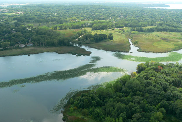
John Reimer from Land & Water Resources and Professor Chin Wu from the University of Wisconsin’s Civil & Environmental Engineering Department presented a concept for an area of the river west of Cherokee Lake, which lies along Burning Wood Way in the Cherokee Park neighborhood.
To improve water quality and reduce shoreline wetland loss, the concept envisions a series of constructed rock peninsulas along the river’s west shoreline. The peninsulas would capture sediments and channel the river’s flow. Two additional peninsulas would re-establish the spits of land that were left when Cherokee Lake was dug in the early 1960s but have since eroded away.
Before refining the plan and seeking funding, county staff want to know if there is public support for the concept. Information from the meetings will eventually be available online. When available, we’ll post links at Cherokeemarsh.org.
A second, identical, meeting will take place Thurs, November 14.If you have an interest in the future of the upper Yahara River, please consider attending this meeting.
Thursday, November 14
6:30 – 6:45 p.m. (Welcome and Project Background)
6:45 – 8:30 p.m. (Breakout Stations)
Westport Town Hall
5387 Mary Lake Road
Waunakee, WI
Learn about & comment on a long-term plan for the Cherokee-Yahara River Estuary
 See below for a media release inviting folks to learn about and comment on a “long-term plan for a portion of the Cherokee-Yahara River Estuary.” We don’t know anything about this project beyond what the release says. We encourage everyone with an interest in the health of Cherokee Marsh and the upper Yahara River to attend. Note there are two meeting dates and locations.
Jan Axelson
Friends of Cherokee Marsh
Dane County, City of Madison, Town of Westport, Wisconsin Department of Natural Resources, and UW-Madison Invite Public Comment for the Cherokee-Yahara River Estuary at Two Public Informational Meetings: November 5 and 14, 2019
The Dane County Land and Water Resources Department was awarded a planning grant from the Wisconsin Department of Natural Resources Department to create long-term plan for a portion of the Cherokee-Yahara River Estuary. The objectives of the plan are to enhance (i) recreation, (ii) fishery and wildlife, (iii) water quality and vegetation, and (iv) erosion and sediment trapping in the estuary.
For each of the meetings below, an introduction and general background of the project will be provided. Then the public will provide input at four breakout stations. Representatives from Dane County, City of Madison, Town of Westport, DNR, and UW-Madison will be at each station to provide information and seek public input.
Tuesday, November 5
6:30 – 6:45 p.m. (Welcome and Project Background)
6:45 – 8:30 p.m. (Breakout Stations)
Warner Community Recreation Center
1625 Northport Drive
Madison, WI
Thursday, November 14
6:30 – 6:45 p.m. (Welcome and Project Background)
6:45 – 8:30 p.m. (Breakout Stations)
Westport Town Hall
5387 Mary Lake Road
Waunakee, WI
Northsiders guide the Friends of Cherokee Marsh into its second decade
-and-Dorothy-Wheeler-discuss-an-issue.")
Jan Axelson (left) and Dorothy Wheeler meet in the marsh to discuss an issue. Photo by Anita Weier.
Anita Weier
(A version of this article appeared in the Northside News.)
Jan Axelson credits her dedication to protecting and restoring Cherokee Marsh to her enjoyment of Wisconsin’s natural wonders after moving to Madison from New Jersey for college. “I had no mentors growing up regarding environmental activism,” she said. “I credit Wisconsin with giving me an environmental consciousness.”
Dorothy Wheeler did have a mentor – her father Richard A. Hemp, who served on the state Natural Resources Board and loved the outdoor world. She recalls the polluted Wisconsin River that flowed through the paper mill town where she lived and how it got cleaned up after laws were passed that made dumping waste into the river illegal.
Both women have served on the Board of the Friends of Cherokee Marsh for 10 years – ever since the organization was started to protect the marsh from development. (Two others, Janet Battista and Muriel Simms, have served for nine years.) All four are Northsiders. Read more
Volunteers celebrate achieving 6-year goal
 Jan Axelson
On Sept 29, we celebrated the completion of six years of volunteer efforts to remove invasive phragmites (giant reed grass) from an area of high quality vegetation in the Cherokee Marsh State Natural Area (SNA). We will need to return periodically to remove resprouts, but the first and most time-consuming pass through the area is now complete.
We began the project in 2012 at the suggestion of the Wisconsin Department of Natural Resources (DNR)’s newly hired volunteer coordinator, Jared Urban. Stands of phragmites were becoming so dense that the diverse, original native wetland plants were being crowded out. Read more
Adventures of a first year bluebird monitor

Jim Mand (left) and Paul Noeldner check a bluebird box and trail cam.
Jim Mand
Having just finished my first season as the Cherokee Marsh North Unit bluebird monitor, I’d like to reflect on what I have learned.
Having first joined Friends of Cherokee Marsh in 2009, I was not actively involved. But after retiring last year on Labor Day, I was looking for opportunities to contribute.
Volunteer Paul Noeldner mentioned that the group needed a bluebird monitor, and since I only live up the road from the marsh at Cherokee Condos and have had a life-long interest in birds and wildlife, it seemed like an ideal opportunity. And it gives me a chance to get out in nature and hike the trails for two hours while checking the nest boxes. Read more